We love our city and we really love our foreshore. That’s what the walkers, cyclists, families, dog walkers, picnickers and park visitors say. Now the Council is asking us what to do to make it even better.
There’s an info session on 17 July at 6 p.m. at the Community Hall in South Terrace. There’s a web page to find out more and submit your ideas. (Click here)

This is where the Wadjuk clan of the Noongar people camped, fished and lived in summer time for millennia. They called the river Derbal Yerrigan. Since white settlement in 1829 much has changed. During the 1890s gold rush days Perth grew rapidly. That’s when the State was proclaimed, many famous buildings were erected, sports clubs begun and engineering changed the landscape. That’s also when Chinese gardeners set up in South Perth, helping to feed the hungry settlement. The Black Swan dredge made a channel from Barrack Street on the north to Mends Street in South Perth, dumping sludge that formed the base of what’s now Sir James Mitchell Park.
Later the Kensington Park track area was developed here for horse racing. You can still see the shape of the track in Google Earth. In the 1920s racing moved to Belmont and the track was used for joy flights. Meanwhile a lot of building rubble and household rubbish was dumped on the river bank. Over time the area filled with more dredged silt, rubbish and some unpleasant chemicals. The surface was eventually levelled and the park built on top of it all.
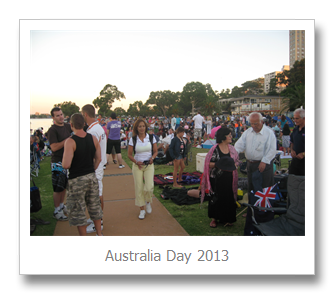
Today it’s a beautifully open space with spectacular views. Nearby is Perth Zoo, WA’s biggest tourist attraction. The new cycle path is really popular. Our annual Australia Day celebration is the best in Australia. New immigrants and old families share the park, living the “Aussie lifestyle.”
Every year the South Perth Council spends over a million dollars maintaining the park. In recent years storms have broken the river walls and flooded the park edges. Groundwater level is at the same elevation as the river water and sits just below the grass roots. Our local sea level has been rising about 3mm a year. That could give us about thirty years until parts of the park are under water. Meanwhile the groundwater flow is flushing fertiliser and some toxins into the river, threatening fish and dolphins.
My dream is that we can:
· Protect the park that we love
· Defend the open space that we share with each other
· Preserve what we value
· Plan for a future so others will enjoy the foreshore just as much

Some things that that people have suggested we might talk about at the info evening are to:
· Use “soft engineering” to dissipate wave energy
· Improve public transport for easier access
· Use digital maps to define likely water flooding limits
· Design new facilities to allow for high water or to be moved or raised later
· Increase the barbecue and picnic facilities
· Possibly allow some small commercial facilities near the foreshore
· Reduce the City’s risk by identifying water level hazard in approvals
· Work together with other Councils to manage the river and riverbanks, with shared strategies, budgets and lobbying power
· Allow public access to data on river and park analyses, costs and usage
· Find ways to reduce our emissions in groundwater and air
· Find ways to provide more shade trees while protecting great views
· Construct more separate cycle and walk paths
· Protect and improve nesting areas for swans and other birds
· Encourage dog exercisers while protecting walkers and wildlife
· Preserve the areas of heavy use while applying less water and fertiliser on less-used parts of the park
What are your thoughts? Got some ideas? Click on Comments, below, or email me. See you on 17 July.
6 comments:
Great blog entry Peter.
As a regular cyclist around the south of Perth I would like to make one comment regarding what I believe is one particularly dangerous spot.
If a cyclist riding west to east approaches Douglas Av the bike path turns towards the car park now and crosses adjacent to the first car in the car park.
This is a blind spot and it concerns me the possibility of car bike collision.
It could easily be fixed by moving the junction back to its original position about 20 yards to the west.
In addition in heavy congested areas I would like to suggest that you put up low bush around the edge of the path. This will act as a visual marker to pedestrians crossing the bike path without looking.
James Cooper
Great blog entry Peter.
As a member of the Sir James Mitchell Park Advisory Group I am pleased to see this post Pete. We want as many people as possible to be aware of this planning process and the survey.
My personal aims for SJMP include :
1. Increased recogntion of Aboriginal culture including plant use.
2. Environmental education.
3. Increased recognition of past uses such as Chinese market gardens, farming etc
I believe these 3 things can be combined in at least one sustainable garden.
I wasn't aware of the racetrack - thanks.
Thanks Peter. This really is informative stuff.
Thanks for blog. I am in Kimberley so unable to access it properly. I get back on 17th so may not be able to attend meeting. I would like to see the bronze plaque installed commemorating the Chinese gardens. I know one was made but previous query has not resulted in action. Similarly we need the indigenous history of the mill recorded there. Work was done but it was never finalised. Very overdue records of our history still missing!
Good luck.
Post a Comment